


Crête de Matacharre Pic Chauve

rigol05
User
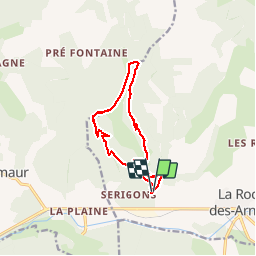

Length
11.8 km

Max alt
1744 m

Uphill gradient
869 m
Km-Effort
23 km

Min alt
937 m

Downhill gradient
868 m
Boucle
Yes
Creation date :
2018-11-05 18:13:00.894
Updated on :
2018-11-05 18:36:35.087
--
Difficulty : Unknown

FREE GPS app for hiking
 SityTrail
IGN / Geographical institutes
SityTrail Plus
The world is yours!
About
Trail Walking of 11.8 km to be discovered at Provence-Alpes-Côte d'Azur, Hautes-Alpes, La Roche-des-Arnauds. This trail is proposed by rigol05.
Positioning
Country:
France
Region :
Provence-Alpes-Côte d'Azur
Department/Province :
Hautes-Alpes
Municipality :
La Roche-des-Arnauds
Location:
Unknown
Start:(Dec)
Start:(UTM)
732390 ; 4938938 (31T) N.
Comments